CHAPTER 15.0 VEHICLE INTERCEPT AND EXTERNAL STATION SURVEYS
Note: Significant components of this chapter come from Chapter 7 of the FHWA Travel Survey Manual. Material has been reviewed and updated by Jerry Everett, Steve Ruegg and Rob Tardiff.
Vehicle intercept surveys are conducted to collect profiles of vehicle trips that use a specific roadway segment. The surveys commonly collect origin and destination data, as well as other information, such as trip purpose, auto occupancy, and trip start and end times. The most common use of this survey type is the external station survey, in which survey teams gather the vehicle trip information at the boundary of the model study area to develop external-external and external-internal vehicle trip tables for the model.
Vehicle intercept surveys are also used at roadway segments within the model study area to provide additional origin-destination data from which to calibrate or validate travel demand models. Vehicle intercept surveys are also conducted at these internal locations to gather travel behavior information for interim travel demand model calibration efforts in lieu of expending the substantial resources required to collect household travel survey data.
Typically, household travel survey data have been collected in a particular metropolitan area every 10 or 15 years. The planning agencies then use vehicle intercept survey data, in conjunction with other survey collection efforts (such as transit on-board surveys), to estimate their regional travel modeling systems. Every five years or so, the agency may re-calibrate their estimated travel models to create incremental or interim regional travel models. In most cases, less expensive data collection efforts, such as traffic count programs and vehicle intercept surveys, are used to recalibrate travel models to match existing highway and transit conditions.
Vehicle intercept surveys are also commonly used at specific sites to analyze the potential traffic effects of proposed new developments or infrastructure improvements.
15.1 Organization of This Chapter
Since the publication of the 1973 travel survey manual, the vehicle intercept and external station survey has been used extensively for these and other reasons (U.S. Department of Transportation, Federal Highway Administration, 1975). The survey methods and procedures described in the 1973 guide are still commonly accepted and practiced, but over the years, technologies, such as improved camera equipment, hand held computers, and CAPI, have improved traditional vehicle intercept survey techniques.
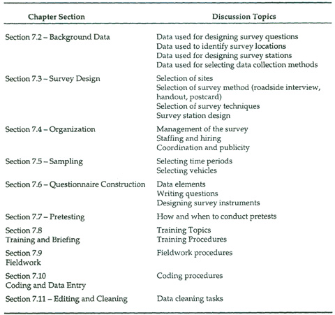
The key issues discussed in each section are outlined in Table 15.1.
15.2 Assembly of Background Data
Three types of background data are useful for designing and implementing vehicle intercept surveys:
· Data used for designing survey questions;
· Data used to identify survey locations; and;
· Data used for designing survey stations and selecting data collection methods.
15.2.1 Background Data to Help Design Survey Questions
Because vehicle intercept surveys are commonly used in conjunction with other previous or on-going survey efforts, it is important that the survey team obtain copies of any survey instruments from complementary survey efforts. As discussed in Section 15.6, the vehicle intercept survey questions should be consistent with questions on the other surveys in terms of:
· Matching or consistent response categories;
· Same level of detail; and
· Same concept definitions
·
The survey team should obtain any recent survey efforts from the sponsoring agencies, and prior to conducting any data collection the team should determine how different data sources can be combined for the anticipated analyses, and what effect these analytical needs have on sample design and questionnaire design.
15.2.2 Background Data to Help Identify Survey Locations
Often, the identification of survey locations is defined for the survey team by the survey data requirements. For instance, travel demand modelers may have pre-specified locations for external stations, or else the survey may be related to the analysis of one or more specific roads. However, for other analyses, the survey team may need to decide where surveys are to be conducted. Particular studies may have specific study area boundaries, around which external vehicle surveys are desired only for the most important highways. Similarly, analysts may want survey data for key screenline locations, but resource constraints may require the survey team to choose only a sample of the locations.
If the survey team is in the position of determining survey sites, the following data sources are likely to be valuable:
· Existing origin-destination trip table information, including Census Journey-to-Work data, that will help define the desired movements within the study area. Even if the data are outdated or are scheduled for revision, these sources will give the survey team a feeling of the relative importance of different interzonal flows.
· Road maps and highway network maps illustrating the project “study area” and the potential areas for survey locations.
Table 15.1 Organization of the Vehicle Intercept Survey Section
· Existing travel demand models with which highway assignments and select link analyses can be performed.
· Permanent traffic count station information describing the roadway attributes, typical traffic volume flows by time period, and vehicle mix by station location (this information may be available from State Departments of Transportation (DOTs) responsible for certain roadways).
· Additional traffic volume flows, vehicle mix, and auto occupancy data describing the attributes of potential survey locations (this information may be available from local traffic engineering and planning departments, private consultants, and developers).
The survey team will need to choose the survey sites (or at least narrow the options) based on the survey data needs and these data sources.
15.2.3 Background Data to Help Design the Survey Procedures
Once roadways are identified, the survey team needs to collect detailed information about the relevant segments of the roads to design survey procedures in detail.
Specific background information sources to be assembled for survey site design include the following:
· Aerial photographs describing roadway contours, terrain, and intersecting bridge-overpass locations to assist in designing potential survey locations; and
· For each potential survey location, roadway cross section diagrams describing roadway section widths, number of travel lanes, median and shoulder widths, traffic signal and intersecting roadway locations, bus stops, parking spaces, and sidewalk widths.
·
·
These data may be obtained from the agencies responsible for jurisdiction of the roadways under consideration. In most cases, major highway facilities such as freeways, highways, state routes, and principal arterials fall under the jurisdiction of State DOTs. In some states, most secondary and major collector roadways are also owned by State DOTs. Other lower level roadway facilities, such as urban primary arterials, may fall under the jurisdiction of county and city/town DOTs and/or Departments of Public Works.
Assembling roadway design information is generally a slow process. Formal written requests for this information are often required. The process for obtaining these data includes the following steps:
1. Establish contact with the appropriate agency responsible for the roadway(s) to be surveyed. Outline the reasons for the survey and identify the project sponsor(s) responsible for the survey.
2. Outline the specific background data needs in a formal letter of request. This request should be sent to the appropriate staff person identified in the initial contact.
3. Following Steps 1 and 2, schedule another telephone or in-person interview with the identified staff person. Interviews should be scheduled at least two-weeks after the initial contact to allow adequate time for agencies to compile the requested data.
4. Collect all relevant information via in-person meeting, mail, or electronic mail.
In some cases, the formal process outlined above may not have to be followed, but the survey team should allow extra time for this data assembly task.
15.3 Vehicle Intercept Survey Design
The survey team has four key issues in designing the vehicle intercept survey:
1. What sites should be surveyed?
2. What survey method should be used at each survey site?
3. Given the survey method, what data collection techniques should be used?
4. How should the survey stations be designed?
These issues are described below.
15.3.1 Site Selection
There are two elements of the site selection process for vehicle intercept surveys. First, the survey team needs to identify the roadway segments that should be surveyed. This task may or may not be necessary, depending on the reason for the survey. Second, the survey team needs to identify the precise location of the survey station within a selected roadway segment.
15.3.1.1 Selection of the Roadway Segment
If the survey team is performing the vehicle intercept survey to analyze a specific highway or a well-defined corridor, the highway segments that need to be analyzed may be obvious. Similarly, if the survey team is seeking to perform an update of a previous vehicle intercept survey effort, then the task of selecting the roadway segments to be surveyed is trivial.
However, in many cases, the survey team must define the best set of highway segments to include in the survey for a particular anticipated analysis effort. Of course, the key parameter in making these selections is the precise nature of these analyses, so it is difficult to describe the best selection strategy. However, a few common approaches can be defined for one type of vehicle intercept survey analysis, the development of origin-destination trip tables.
In many cases, the survey team’s primary interest in the vehicle intercept survey data is to develop origin-destination trip estimates for vehicle trips entering (or leaving) the study area of interest or for vehicle trips crossing a pre-defined model screenline or cutline. The first step, of course, is to identify the boundary line.
In the case of defining a travel model study area, the 1973 Urban Origin-Destination Survey Manual provides the following guidelines for the determination of study area boundaries (cordons):
1. The cordon line should include entire political jurisdictions, e.g., towns, cities, Census tracts, special districts. This is more convenient for assembling and analyzing existing data, it establishes a better basis for good relations with those jurisdictions, and it gives an improved ability to serve all agencies.
2. The cordon line should also include the various planning boundaries that have been established, such as the Census Urbanized Area and the Federal Aid Urban Area.
3. The cordon line should not extend through a network of streets or roads that would necessitate an excessive number of cordon crossings.
4. If possible, the cordon line should intersect all roads at points which are suitable for performing vehicle intercept external surveys.
5. If possible, the general course followed by the cordon line around the study area should be uniform in nature, without major deviations inward or outward. This will help to eliminate double crossings at the cordon, as well as any unusual travel patterns in the traffic assignment process. If a natural boundary, such as a river, is available, it should be considered for use as the cordon boundary.
6. If the cordon line is closely parallel to an existing or planned transportation facility that serves internal traffic, the cordon line should be placed so that the facility falls inside rather than outside the study area.
7. All dwelling units in the vicinity of outlying public transit stations should be included inside the cordon line, if possible.
8. Special generators, such as airports and military bases, located in the outlying fringe areas should be placed inside the cordon, if possible.
Since boundaries and screenlines are often crossed by more highways than the survey team is willing or able to survey, the survey team may need to select a subset of highways. Two approaches are commonly used to perform the selection of roadway segments:
· Select the segments with the highest traffic volumes; and
· Select the highway segments that are likely to provide the most origin-destination information.
The first approach simply involves reviewing the most recent traffic count data for the candidate segments, and then selecting the highest volume locations that can be surveyed with the available cost and time resources. This simplistic method is the most common site selection approach, but it has a few drawbacks. First, new traffic count information may need to be obtained (or estimated) for some segments before they can be compared to others. Mid-level and lower volume highway segments may not have recent traffic count information to make the selection. Second, sometimes lower volume highway segments provide key origin-destination information that would be valuable for trip distribution modeling.
A better approach to selecting roadway segments for origin-destination analyses is to use available trip table information and highway assignment and selected link analysis output from an existing travel demand model, if one is available. By analyzing the model output, the survey team can determine the combination of roadway segments that provide the most origin-destination information for the available resources. Adler, et al. recently applied a mathematical programming model to highway network model output to optimize the selection of vehicle intercept survey sites (Adler et al., 1995). Other planners have used far less rigorous approaches, combining simple decision rules and approximations to obtain an effective (though, possibly not optimal) combination of survey sites.
15.3.1.2 Selection of the Survey Site Within a Chosen Roadway Segment
Once a highway segment has been identified for the survey effort, the survey team needs to review the physical and geometrical features of the segment to determine the best site for the survey. The highway segment review can be accomplished in two steps. First, the survey team can evaluate any available detailed information on the roadway segment, possibly including aerial photographs, highway geometric summaries, and maintenance management information. With this information, the survey team can perform preliminary screening of specific sites, and identify those segments that appear not to have suitable survey locations.
Potential survey sites should be evaluated on the basis of:
· Sight distance;
· Proximity to intersections, on-ramps, etc.;
· Vertical and horizontal curvature;
· On-going repair and construction projects;
· Shoulder width;
· Availability of overpasses (see license plate survey description below); and
· Traffic signals and tollbooths.
After the preliminary screening, the survey team should conduct field inspections of each roadway segment to confirm the preliminary evaluations.
If no suitable survey sites can be identified within a particular highway segment, the survey team should consider the possible consequences of surveying adjacent segments upstream or downstream from the original segment. A small shift in the survey location often greatly complicates survey analysis, because some trips may be ineligible for analysis. For instance, if a roadway segment outside of an external boundary were used, the survey team would need to factor out those trips that did not enter the actual study area, or that could have crossed into the study area on a highway segment that is already being surveyed. In cases where the small shift in survey location is considered to be a problem, the survey team should choose another eligible highway segment.
15.3.2 Survey Methods
There are four general methods for conducting vehicle intercept surveys:
· The license plate survey – Fieldworkers record the license plate numbers of vehicles passing the survey location, the vehicles’ owners are determined using data from one or more state’s Department of Motor Vehicles (DMV), and the vehicle owners are then sent a mail survey.
· Roadside handout survey – Fieldworkers stop some or all vehicles passing the survey location, and hand out self-completion mailback survey forms.
· Roadside interview survey – Fieldworkers stop some or all vehicles passing the survey location, and conduct short interviews with drivers.
· Combined Roadside Interview and Handout Survey – Fieldworkers stop some or all vehicles passing the survey location, conduct short interviews with drivers, and then hand out self-completion mailback survey forms.
15.3.2.1 The License Plate Survey
Figure 15.1 shows an example process diagram for a license plate survey. At the survey site, the survey team observes and records license plates of cars passing the survey station. As discussed below, there are several data collection techniques for achieving this, but none will be perfect, so a certain percentage of vehicle license plates will not be recorded. The registration numbers that are recorded are entered into a database, which is then merged with one or more Department of Motor Vehicles (DMV) vehicle registration databases. The vehicle license plate numbers are matched with auto owners and their addresses.
If an address match is found, the survey team mails the vehicle owner a survey form requesting information about the trip that was being taken when the license plate was recorded and/or about other topics. The survey then follows the same course as a standard mail survey, with optional follow-up mailings and clarification.
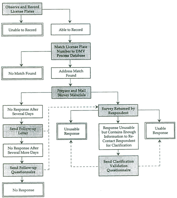
Figure 15.1 Process Diagram for an Example License Plate Survey
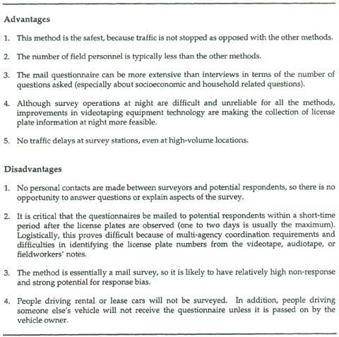
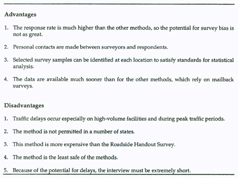
Table 15.2 describes the advantages and disadvantages of the license plate survey. Because it is the only method that does not require stopping traffic, it is usually the preferred approach for high-volume locations. Roadways with a daily traffic volume of less than 10,000 vehicles usually will not yield a sample size that is useful for most analyses. The main challenges of the method are to be able to convert the raw license plate data into a name and address list in a very short period of time, and to get respondents to reply to the questionnaire in a timely fashion. The longer it takes to get the survey to the vehicle owner, the more likely the results will suffer from recall problems and non-response. As an alternative, the survey instrument can ask about the last time a traveler used the roadway segment in question.
The license plate survey requires the survey team to complete the following preliminary design steps:
1. Establish contact with the appropriate local agencies and departments requesting cooperation, permission, and support for the survey effort. Contacts should be made with the appropriate agencies responsible for jurisdiction of the roadway(s) to be surveyed; the local Department of Motor Vehicles and the DMVs of other states from which the survey team will need to seek data; and the state and local police departments. This support is required to proceed with the license plate survey effort because staff from each relevant agency will need to provide the go-ahead and potentially participate in the survey effort. (This step should be established well in advance of the subsequent steps to obtain agency approvals for the survey effort.)
2. Identify the roadway locations and time periods for surveying, as discussed above.
3. Conduct a field inspection of the roadway locations to be observed. The purpose of the inspection is to determine the logistical needs of the survey including the crew, equipment and supplies, coning, police setup, and license plate identification operation requirements. This should be conducted at each roadway location to be surveyed.
4. Develop the questionnaire mailout logistics. The cooperation of DMV, and the quick turnaround of address information of the observed vehicles are developed during this step. The quick turnaround of address information is necessary to ensure that persons traveling on the surveyed roadways receive questionnaires within a few days after using the roadway.
15.3.2.2 The Roadside Handout Survey
The roadside handout survey is an example of an intercept/self-administered survey. A typical process diagram for this type of survey was shown in Figure 3.9. In the roadside handout survey, the survey team establishes a survey station at a location where some or all motorists are directed to slow to a stop, and then are asked by fieldworkers to complete a self-administered survey form, and to mail it back. Once the forms have been distributed, the survey team must simply wait for replies.
Table 15.3 describes the advantages and disadvantages of this method. The roadside handout survey is superior to the license plate survey in that it has lower processing costs. In addition, it provides the opportunity for fieldworkers to screen potential respondents. For instance, if a particular survey is interested only in people who live outside a study area, then the fieldworker could ask a short question of the driver and distribute the forms only to relevant individuals. The main drawback of the method compared to the license plate survey is that it is disruptive to traffic. The survey team also loses the ability to follow up with non-respondents, unless they are tracked using DMV files, as for the license plate survey.
The roadside handout survey is generally used on medium volume roadways (8,000 to 12,000 vehicles per day) because it is less expensive than the license plate survey and less disruptive than the roadside interview method.
15.3.2.3 The Roadside Interview Survey
The third survey method, the roadside interview survey, is a form of the simple interview survey, as diagrammed in Figure 3.8. As in the roadside handout survey method, the survey team stops vehicles at the survey site, but rather than asking drivers to fill out a form, the fieldworkers perform short interviews.
The advantages and disadvantages of the roadside interview survey are shown in Table 15.4. The method is far more disruptive than the license plate or roadside handout survey, but the high response rate relative to the other methods means that the survey data are likely to be of substantially higher quality. The response rate for this method could be up to five times higher than for the other methods. The method is primarily used on lower and medium volume roads.
15.3.2.4 Combined Roadside Interview and Handout Survey
A common variation on the basic methods is to combine the roadside handout survey and the roadside interview survey. The survey team intercepts a vehicle passing the survey location, and an interviewer asks the driver of the vehicle a few questions. When the short interview is completed, the interviewer gives the driver a mailback questionnaire with more detailed questions.
The primary advantage of this approach is that a small amount of data are collected from potential respondents before they answer the main questionnaire. This allows the survey team to perform screening of potential respondents, and to provide potential respondents with customized mailback questionnaires. For instance, study area residents can be given a different questionnaire than non-residents. In addition, based on the interview data, the survey team is able to detect and possibly correct for systematic non-response bias in the mailed survey returns. The main problems with the approach are that it is more expensive and that it disrupts traffic almost as much as the roadside interview survey.
Table 15.2 Advantages Survey and Disadvantages of the License Plate
15.3.3 Data Collection Techniques
Depending on the data collection method to be used, the survey team has a variety of data collection techniques available.
15.3.3.1 Data Collection Techniques for License Plate Survey
Travel surveyors have applied a number of approaches for observing and recording vehicle license plates, including the following:
· A fieldworker observes a license plate and then simply writes the number down. The written notes are then entered into a data file in the office.
· A fieldworker observes a license plate and reads it into a tape recorder. The audiotape is then transcribed into a data file in the office.
· A fieldworker enters the license plate number directly into a portable computer, or reads it aloud to another fieldworker who performs the data entry.
· A fieldworker sets up and monitors a video camera that records license plates. The videotape is then sent to the office for data entry.
The selection of the best technique depends on a number of practical considerations and constraints. The most basic technique, having fieldworkers simply write down passing license plate numbers, has the advantage of simplicity. There is no equipment to maintain or keep track of. The fieldworker is completely mobile, and he or she can adapt to unforeseen conditions. Unfortunately, the simple data collection technique is likely to have the most problems in converting the numbers into the data file. It is common for fieldworkers to reverse digits or make other entry errors, or to write illegibly since they are in a hurry to record many license plates. Having the fieldworkers read the numbers aloud into a tape recorder reduces the number of errors in the field and frees the fieldworkers’ hands to use binoculars, but because survey locations are likely to be quite loud, it is often difficult for office staff to transcribe the tapes.
Table 15.3 Advantages and Disadvantages of the Roadside Handout Survey
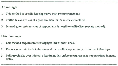
Table 15.4 Advantages and Disadvantages of the Roadside Interview Survey
In cases where a tape recorder is used, a microphone which reduces background noise (directionality, and range) should be chosen.
Some surveyors have tried to eliminate the need for office data entry by having fieldworkers enter the data directly into portable personal computers. The technique can reduce survey costs, but it has the same disadvantage of most computer-assisted survey techniques – there are no raw source documents. The only record the survey team has is the data file itself, and perhaps a printed record of the file once the data are brought to the office. With the other techniques, there are handwritten, audio, or video records that can be referenced, if necessary. It should also be noted that lack of familiarity with the portable computers may cause slower data entry relative to written or recorded data entry. Small inefficiencies can be a problem at high volume locations.
An increasingly popular observation technique is the video data collection approach. In this method, a video camera is aimed at one or more traffic lanes and is used to simply tape all vehicles going by. A fieldworker usually monitors the video taping, but is not needed for any active data collection. The technique can be highly effective for multi-lane high speed traffic locations, because fieldworkers recording information at these sites can become overwhelmed.
The technique is usually cost-effective for sites that would require more than one fieldworker to observe license plates directly, because a single person can monitor more than one video recorder. Videotaping has the following additional advantages (Baker, Deardorf and Cathy Strombom, 1995):
It can be used at sites where it would be impossible to station fieldworkers for extended periods;
· It is more accurate than the other methods if taping is carefully monitored;
· It can be used to provide additional data about the survey site, including the classification of vehicles and vehicle occupancy; and
· The use of videotape data collection is expanding in a number of fields, and so it is possible to locate specialist companies that are quite experienced with the required procedures.
The technique does have some problems, however, such as:
· It requires renting high quality video recorders (typically, top-of-the-line equipment is needed to capture the license plates of vehicles traveling at 60 miles per hour or more);
· Transcribing license plate information from the videotapes can be a tedious process (survey office workers need to fast-forward the tape to just the right moment, record the license plate, and then repeat the process again and again); and
· The survey site is less flexible, and harder to adapt if special unforeseen circumstances arise (such as an unexpected lane closure or a rain shower).
Some researchers are now using automated collection and transcription of license plate data from videotapes. This development will not only reduce the cost of the survey since office screening and transcribing of license numbers would not be needed, but potentially would increase the accuracy of the data and provide a larger sample (i.e., more license plate “matches”).
15.3.3.2 Data Collection Techniques for Roadside Interviews
Roadside interviews can be performed using conventional paper and pencil interviewing (PAPI) procedures or by using computer-assisted personal interviewing (CAPI) procedures. A number of recent studies have taken advantage of CAPI techniques for roadside surveys, including efforts in Florida, Georgia, Texas, New Hampshire . Muntean lists the following advantages of CAPI for roadside interviews (Muntean, 1995):
1. Real-Time data entry and coding
-
- Direct data entry to data file
- Creates an electronic record of surveyor productivity with a benchmark for the site team
2. On-Site Editing
- Instantaneous validity check
-
- Sip routine
- Interviewer can review record upon completion of interview,
3. Automatic Geocoding
- Computer provides interviewers with place name look-up tables,
- Interviewer can scroll through list or type first several letters to find the place name
- Database can record zone number, as well as place name
These advantages have been realized in other studies, as well. As described in other chapters of this manual, CAPI also provides other advantages. However, because roadside interviews are by necessity relatively short, survey teams often do not require advanced capabilities.
The primary disadvantage of the CAPI technique is the expense of obtaining usable laptop or palmtop computers, or personal digital assistants (PDAs). Although the unit costs of these machines have dropped precipitously, most survey efforts require the purchase or rental of several machines. The computers used in roadside interviews need to (Anderson, 1994):
Be small and lightweight;
· Have sufficient battery life for daily survey needs;
· Have a sunlight readable display;
· Have means of easily transferring data to office computers;
· Have time-of-day stamping capabilities;
· Have sufficient memory for the survey program; and
· Have sufficient storage space for a day or more of surveys.
15.3.4 Survey Station Design
15.3.4.1 The Design of Roadside Survey Stations
The final element of the survey design that is critically important is the design of the survey station. Roadside handout and interview surveys require survey fieldworkers to work in and around moving traffic, and, because most respondents will have never been asked to participate in such a survey effort, they are not likely to fully understand what they are supposed to do. Therefore, it is essential that the survey team carefully design the survey station to be as safe and clearly understood as possible.
The survey station design is affected by:
The survey method license plate, roadside handout, roadside interview, combined method (in particular, the amount of time vehicles need to be stopped)
The volume of traffic on the highway segment;
The roadway geometry (in particular, the roadway and shoulder width);
The availability of trained fieldworkers; and
The percentage of vehicles passing the station that are needed for the survey.
The survey team needs to work closely with highway engineers and local law enforcement agencies to develop station designs and survey procedures that are acceptable in terms of safety and the potential effect on traffic flow.
Figures 15.2 and 15.3 show some example survey station designs, but the survey team will probably want to customize their sites to match local conditions and specific survey needs. For instance, if the roadway traffic volume will support it, many survey teams use several interviewers or questionnaire distributors. Instead of intercepting a single vehicle at a time, an entire platoon of vehicles is intercepted together. In addition, some sites will allow for vehicles traveling in the survey direction to pass the survey station in a second lane while interviews are taking place, while other sites simply will not be wide enough.
Figure 15.2 Sample Vehicle Intercept Mailback and Interview Traffic Control Plans from Vermont
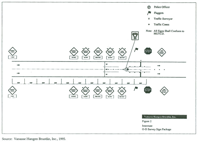
Figure 15.3 Sample Vehicle Intercept Survey Site Design for Interstate Highways
At a minimum, all roadside interview and roadside handout stations require the following:
1. Extensive signage, warning motorists of the survey (some survey efforts have used variable message signs);
2. A large number of traffic cones for channelling traffic;
3. Safety equipment for fieldworkers (orange vests, hard hats, etc.);
4. Supervisors and flaggers who have experience working in traffic; and
5. A police detail.
Even though police officers are not always required at the site, having officers on hand is usually worth the additional expense. Generally, police departments provide off-duty officers working overtime for efforts such as vehicle intercept surveys. The officers often have police cars available to them which can help attract motorists’ attention to the fieldworkers on the roadway. In some cases, the police officer at the survey site plays an active role in directing vehicles into the survey station. In other cases, the officer simply oversees the safety procedures at the site. The police presence reduces the risk of accidents or incidents, because the officers are trained in safety procedures. In addition, the officers are much better able to deal with irate respondents than most survey crews.
15.3.4.2 The Design of License Plate Survey Stations
The survey station for license plate surveys is much less complicated. The survey team simply needs to locate camera positions which can record license plates from all lanes of passing traffic and that allow fieldworkers to monitor the cameras. The stations are commonly established on highway overpasses. Fieldworkers for license plate surveys will also be near moving traffic as they work, so it is important that personal safety precautions similar to those used on roadside surveys be used.
Figure 15.4 shows an example survey station design for a videotape license plate survey. Like the roadside survey station designs, the license plate survey station designs need to be customized to the particular survey sites.
As discussed below, for both roadside surveys and license plate surveys, it is usually advantageous (or necessary) to conduct vehicle counts at or near the survey station. Usually tube counts are collected a few hundred feet beyond the survey station, and manual classification counts are made throughout the day. The count information is used for expansion of the data.
The organization of the vehicle intercept survey includes the following elements:
· Management of the survey effort;
· Staffing analysis;
· Hiring methods;
· Coordination with other agencies; and
· Advance publicity.
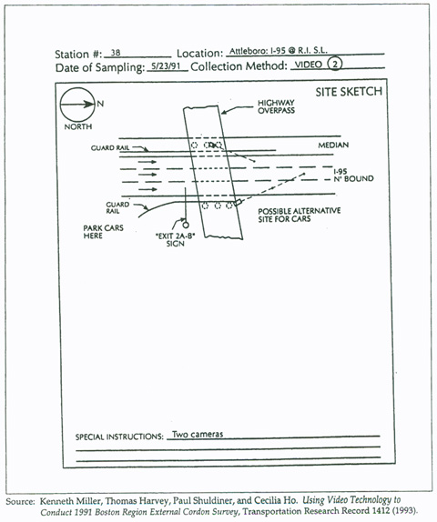
Figure 15.4 Example Vehicle Intercept Survey Design for a License Plate Survey
15.4 Organizing the Vehicle Intercept Survey
15.4.1 Management of the Survey Effort
Chapter 4.0 summarizes the three primary management tasks of travel surveys:
· Overall management and leadership of the effort;
· Day-to-day management of survey fieldwork; and
· Analysis of the survey effort from the data user perspective.
Vehicle intercept surveys present unique management challenges for each task, but perhaps the most important aspect of these surveys from a management perspective is the need to effectively adapt general survey procedures to specific survey sites, each of which is different from the others. Often survey efforts rely on more than one data collection method or technique, and even when the same general procedures are used, they must still be adapted to each site.
High quality field supervision is a key to the success of vehicle intercept surveys. The survey team should ensure that the supervisors understand the goals of the survey effort, and that they are equipped to make on-site decisions about how to solve unforeseen problems without endangering the overall data quality.
15.4.2 Staffing Analysis
The fieldworker staffing needs for vehicle intercept surveys are related to the survey method and the site being surveyed. The staffing analysis should consider attributes of each selected roadway, such as the number of travel lanes, average daily, morning, and afternoon peak-period traffic flows, time periods to be analyzed, and logical and safe survey operation locations. The basic steps presented below are recommended:
15.4.2.1 License Plate Survey
1. Identify the number of roadways, lanes, and the survey times. This information will establish the coverage of roadways to be surveyed. It will also identify specific videotape crew, license identification crew, and camera specifications per survey location.
2. Identify the estimated daily peak-traffic volumes using the roadways to be surveyed. Much of this information may already be available from existing traffic counts or volume estimates. Based on these volumes, define the analysis needs of the survey in terms of sampling (see Section 15.5) and travel demand modeling. This information, in conjunction with the various time periods identified in Step 1, should provide the appropriate level of survey coverage to represent typical peak and daily roadway travel on the selected roadways.
3. Identify the estimated number of license plates to be observed by time period and roadway lane. This information will be required to identify the data collection periods. In most cases, observation can be conducted in hourly segments to facilitate license plate identification and transfer of information for merging with DMV databases.
4. Estimate license plate transcription and data entry rates to determine office staff requirements.
15.4.2.2 Roadside Handout and Interview Surveys
1. Identify the number of roadways and survey times. This information will establish the extent of coverage of the roadways to be surveyed.
2. Analyze the traffic control plan developed during the survey design task for each roadway to be surveyed. This plan includes the setup and control of the roadway survey station. It should include a given number of surveyors, roadway flaggers (for each direction) to slow traffic, a given number of relief surveyors, and one or more supervisors. Each station should have a law enforcement officer on duty to ensure safety and motorist cooperation. This plan also provides information on the effort required for site setup, including coning roadway travel lanes and stationing of advance warning signs.
3. Identify the estimated daily and peak-traffic volumes using the roadways to be surveyed. Based on these volumes, the analysis needs of the survey are defined related to sampling and travel demand modeling.
4. Use the traffic control plan and the traffic volume information to estimate site productivity rates.
15.4.3 Hiring Methods
Based on the staffing analysis, the next task will be to identify the methods for hiring surveyors. The hiring options for the vehicle intercept surveys include the following:
1. Contract with a local or, in the case of the License Plate Survey, a specialized data collection firm to conduct the survey. The data collection firm will be responsible for hiring surveyors, and conducting, administering, and supervising the survey in the field.
2. Contract with a local or specialized data collection firm to conduct the survey with supervision provided by the project sponsor. The data collection firm will be responsible for hiring surveyors and conducting the survey in the field while the project sponsor will be responsible for overall management and supervising the survey in the field.
3. The project sponsor will be responsible for recruiting and hiring surveyors, and conducting, administering, and supervising the survey in the field
In most cases, the license plate survey will be conducted by private consulting firms specializing in this type of data collection. If consultant assistance is obtained for the roadside surveys, most survey teams usually hire traffic engineering firms, as opposed to survey research firms. This is because of the need for experienced traffic personnel. The engineering firms either use in-house staff or hire temporary employees for the work.
If the sponsoring agency chooses to manage the effort themselves, they should schedule interviews with prospective surveyors from various organizations, including college and university employment agencies, planning, and engineering departments; state and local government employment agencies; and private temporary employment organizations. Based on these interviews, the sponsor(s) will select the best qualified personnel.
In most cases, hiring surveyors familiar with the region to be surveyed is important. It may also prove useful for the project sponsor(s) to be involved in the initial administration and supervision of the survey (possibly during the pretest stage) effort to ensure that the surveyors (or local contractor) are conducting the survey properly. In some cases, survey firms have offered financial incentives to temporary survey crew employees to increase retention by increasing the pay for each subsequent week on the job. Loss of surveyors not only requires additional resources to train replacements, but delays the schedule as well.
15.4.4 Coordination
Coordination and communication between the various participating agencies should be established early on in the development and implementation of the vehicle intercept and external station survey. In many vehicle intercept surveys, State Departments of Transportation (State DOTs), Departments of Motor Vehicles (DMVs) from the survey state and perhaps from adjoining states, state and local Highway Patrols, and local Departments of Transportation and Public Works may potentially be involved in the survey effort.
The survey team needs to identify the special concerns of the different agencies early in the survey design. In some cases, agencies, such as State DOTs, require the use of standardized and accepted Traffic Control Plans to be used for vehicle intercept surveying. State DOTs may not allow vehicles to be stopped for surveying. There are also legal implications to stopping vehicles for surveys, including insurance liability issues for data collection firms. This initial coordination between the surveyor and participating agencies is critical to the successful implementation of the survey, and typically helps to identify the acceptable and appropriate survey method early on in the effort.
15.4.5 Advance Publicity
For vehicle intercept surveys, it is highly desirable to publicize the overall effort well in advance of the fieldwork dates. Potential respondents are more likely to believe that the survey effort is legitimate and important if they have heard that the survey will be taking place. This is especially true for the license plate method, because respondents will receive the survey instrument without any notification. The publicity effort is the only effort to alert potential respondents of the effort prior to the actual survey.
However, the survey team should exercise care in providing publicity about the specific sites to be surveyed. If motorists know that roadside surveys are being conducted at a particular location on a certain day, they may change their travel patterns to avoid (or to include) that location. In this case, the usefulness of the survey data is jeopardized, particularly if the collection of origin-destination data is the primary survey objective.
15.5 Sampling
As noted above, the vehicle intercept and external station survey should be developed and conducted simultaneously with either an existing or proposed Traffic Count Program. The purpose of the Traffic Count Program is to identify the level of traffic volumes expected at each vehicle intercept survey location. These traffic volumes can help to define the sample size requirements of the total respondents required for given survey time period.
Each survey method – the License Plate Survey, Roadside Handout Survey, and Roadside Interview Survey – use the same sampling strategy. The typical sampling procedures for selecting sample time periods and vehicles are described in the following sections. A general description of sampling methods and statistical analysis appears in Chapter 5.0.
15.5.1 Selecting Time Periods and Days
The Staffing Analysis of the organizational plan describes the staffing requirements based on specific roadway location, time period, and number of days identified for surveying. Depending on the scale and scope of surveying, the following guidelines should be followed for selecting survey time periods and days:
1. Identify the schedule for surveying. This schedule should describe the start and end dates proposed for the survey. For example, the survey may be scheduled for one month, roughly starting April 1 and ending May 1. In most cases, vehicle intercept surveys are scheduled in the Spring (March through May) and Fall (September through November – before the Thanksgiving Holiday) of any given year.
2. Within the defined schedule, identify the number of potential roadway locations and weekdays for surveying. Vehicle intercept surveys are typically conducted on Tuesdays, Wednesdays, or Thursdays during the week to gather representative samples of weekday traffic.
3. Identify the time periods for analysis. Generally, a 12-hour time period, from 6:00 a.m. to 6:00 p.m., is selected for , but the selected period should be based on the daylight hours. A 12-hour period will provide representative samples of weekday daily, and morning and afternoon peak-period traffic volume flows.
At this point, a detailed schedule for the number of days and time periods for surveying should be identified. Adjustments to this sampling can be made to account for weekend surveying, peak-period surveying, and time extensions (from the spring to fall) because of large scale surveying.
15.5.2 Selecting Vehicles
The selection of the number of vehicles to be sampled is dependent on the number of vehicles using the particular roadway under study. The development of this survey sample should be made based on the most recent traffic volume information available. Typically, vehicle intercept surveys are conducted for 12-hour periods and include the following sampling procedures:
1. Identify the daily two-way directional volumes for each of the selected roadway locations to be surveyed. In some cases, previously collected traffic data can be used to estimate daily traffic volumes. Optimally, newly collected traffic volumes collected from the Traffic Count Program should be used.
2. Identify the proposed sample rate for each of the selected roadway locations to be surveyed. This proposed sample rate is commonly defined to achieve an accuracy of 15 percent (error) at a confidence of 95 percent for a 10 percent proportion of the surveyed roadway’s total traffic having a particular origin and destination. This sample rate equation will provide the expected number of driver responses required at each roadway location.
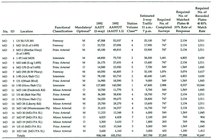
Table 15.5 shows the sample size estimation for a multi-site license plate survey recently performed by the Metropolitan Washington Council of Governments.
During the conduct of the survey, a detailed account should be identified of the expected survey response rate and predicted number of completed questionnaires required for each roadway location surveyed. Adjustments to this sampling can be made to account for low response rates by specific location. For example, roadway locations can be surveyed again to obtain the proposed sample rates.
While the actual response rates, of course, are unknown until the survey is completed, the estimated response rates are critical information in the determination of sample size. The expected response rate will depend on the survey method, the type of roadway being surveyed, and the characteristics of the travelers on the roadway. Surveys which require a mailback response will, naturally, have much lower response rates than in-person interviews.
If license plate matching is used, there is an additional factor in the response rate estimation: the plate match rate. The match rate is the percentage of observed license plates which are recorded and matched to a vehicle in the motor vehicle department file. There are two main reasons why some vehicles will not produce matches:
· The recorded plate is not from a state to which the data file will be sent for matching (usually it will be efficient to exchange data with from only one to three states; it is seldom worthwhile to exchange data for states with only a handful of plates); and
· The plate cannot be read or is mis-recorded.
Table 15.5 Selected Survey Station Sites and Estimated Survey Samples
There are several reasons why license plates are mis-recorded or unread. These include:
· Lack of light, or glare from sunlight;
· Obstructions, such as tow bars, bicycles, and dirt;
· Bad viewing angles, especially for vehicles which are changing lanes or have overhangs above the license plates; and
· Simple recording or keypunching errors.
Although a greater percentage of license plates may be read using video technology, the match rate may be even lower than for plates that are manually recorded. This is because the camera is in a fixed position and cannot “look around” obstructions or at plates that are outside the field of view. Automated plate matching programs can also have high error rates as similar characters (e.g. “D” and “O” “B” and “8”) may be mistaken for one another, and plates that appear visible to the naked eye on a video display are too dirty or unlighted for the program to match. Still the potential savings in labor, both for license plate transcription and data entry, makes the use of video technology attractive and can more than offset the costs of having to collect a greater sample.
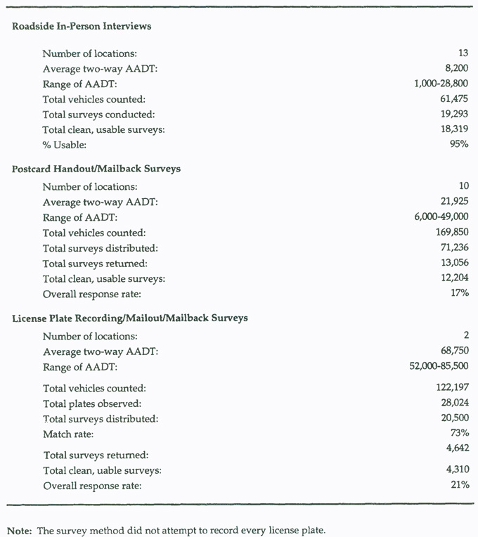
Table 15.6 shows response rates for a vehicle intercept survey in New Hampshire which used three different survey methods. In this survey, the response rate was 17% for the postcard handout/mailback survey and 21% for the license plate recording/mailout/mailback survey. With the match rate at 73%, this survey had an equivalent response rate of 15%. While the response for these two methods turned out to be similar, it should be noted that the license plate method was used only on two expressways on the Massachusetts border in the most heavily developed part of New Hampshire. The license plates were recorded from overpasses, which did not exist in most of the other locations. The same response and match rates might not have been achieved if the license survey were performed at other locations.
Table 15.6 Response Rates from A New Hampshire Vehicle Intercept Survey
15.6 Drafting and Constructing Vehicle Intercept Survey Instruments
Like the other surveys described in this manual, the wording of questions must be carefully considered and consistent with other types of travel surveys recently performed or currently underway. For example, consistent questions about trip-making should be determined for household travel surveys and vehicle intercept and external station surveys if they are to be used together for model development. This ensures consistent information will be collected, especially regarding travel behavior characteristics of persons within a region. In addition, information collected in the vehicle intercept surveys should also maintain consistency with the current Census data specifications. The household, trip, and person information typically collected in the intercept survey should maintain the same categories as specified in the latest Census including breakdowns of income levels, occupation codes, and ethnic status.
Survey instruments and questionnaire designs will be different depending on the survey method selected. General survey instrument and questionnaire guidelines related to the types of questions, survey instrument considerations, and timeframes are provided below.
15.6.1 Data Elements
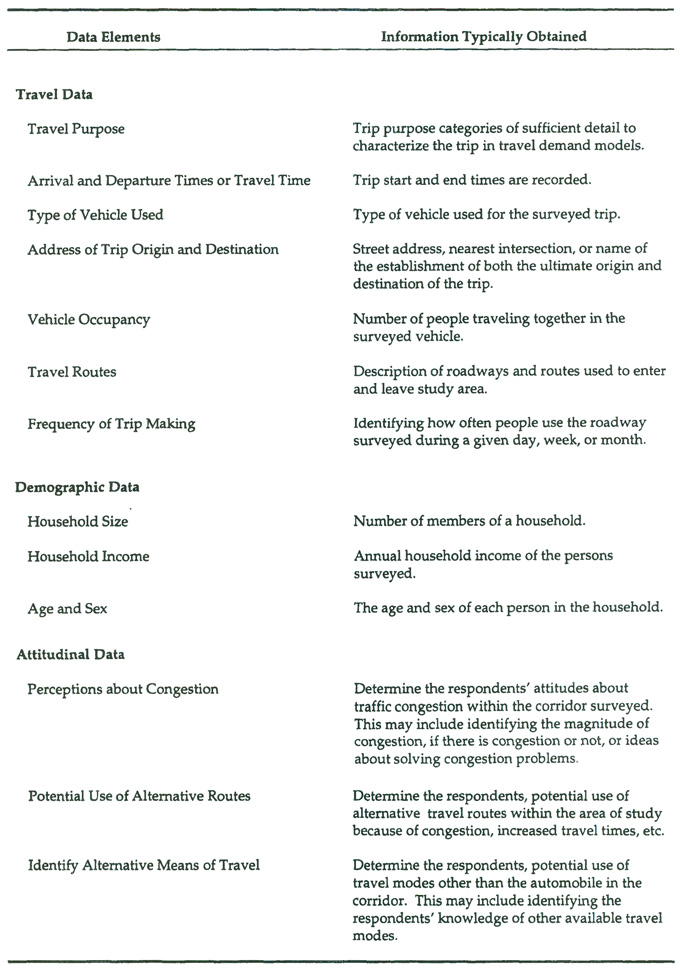
Table 15.7 shows the data elements typically collected in vehicle intercept surveys. Questions should be structured to obtain information about travel and trip-making behavior, households, and individuals. Travel and trip-making behavior questions should include origin and destination locations, vehicle type, trip purpose, and auto occupancy information. Questions about households should include number of available automobiles, household income levels, and number of persons per household. Demographic questions about individuals should include sex, occupation, and employment status information. Vehicle intercept surveys are also commonly used to collect attitudinal and stated-response information from motorists.
Because vehicle intercept instruments are generally very short, the number of data elements collected by these surveys is limited. Many vehicle intercept surveys collect only the barest essentials about the auto trip. Therefore, the range of data elements covered in these surveys is much smaller than for the household travel and activity surveys. The survey team should define essential data elements and other desirable elements that would be included if space or time permit.
Table 15.7 Vehicle Intercept Survey: Typical Data Elements Collected
15.6.2 Translating Data Elements Into Questions and Response Categories
As discussed in Chapter 6.0, a survey question should be included in a survey interview script or questionnaire if:
· The information obtained from the question is relevant to the models being developed or refined, or to other anticipated analytical efforts.
· The question and response categories are expected to be valid measures of the modeling variables.
· The responses can be coded meaningfully for modeling analyses.
· Analysts, interviewers (if any), and respondents agree unambiguously on the meaning of the question and response categories.
· The question and response categories have no wording problems. The wording of questions and responses is the same or equivalent to any measure from other surveys that will be used in the modeling work.
· Response categories exhaust all meaningful answers that can be anticipated.
· Response categories are meaningful and understandable to respondents.
· (For interviews) the questions and response categories are easily learned by interviewers.
· The benefits in the survey analysis from the question outweigh its costs in terms of survey length, respondent burden, and increased non-response.
· The information gained from the question is more useful than the information that would be gained from other questions that will not be on the survey.
· The question does not provoke respondents to be hostile to the survey effort or to question the goals of the surveying agency.
Chapters 2.0 and 6.0 provide detailed guidance on drafting survey questions.
15.6.3 Survey Instrument Considerations
For the License Plate Survey, the questionnaire layout parameters should be identified and implemented based on the types of questions selected, appropriate card stock, page layout formats, and return of address envelopes with postage. This layout should include a brief project description, a request for respondent participation, and a logical organization of the travel behavior, household, and demographic questions. For example, the “to trip” (inbound, to work) and “from trip” (outbound, from work) travel behavior questions should be separated and asked at the start of the questionnaire. Household and demographic characteristics questions should follow the travel behavior questions. The layout should also consider double-sided questionnaires to reduce printing requirements and costs. In addition, an upper limit on the number of questions should be identified to increase the survey response rate. A cover letter, signed by the project sponsor(s) and/or elected officials should also be provided along with detailed instructions for filling out the questionnaire.
Additional instrument considerations must be addressed in the License Plate Survey design to account for unreadable license plates on the videotape, license plate and DMV mismatches, and coding errors when transcribing license plates from the videotape. In addition, the DMV will not be able to identify out-of-state vehicle license plates that could be videotaped on a surveyed roadway. The surveyors must identify the appropriate strategies to account for these potential problems to maintain the established sampling strategy and response rates.
The Roadside Handout Survey can follow the same format as the License Plate Survey. Often, handout surveys include fewer questions, and utilize a postcard style format. This questionnaire form may be limited to questions specifically related to travel and trip-making behavior.
Many survey teams feel that it is imperative to keep the survey instruments as short as possible either because longer instruments require additional expense (in terms of higher postage, need for envelopes, etc.) or because of the concern that response rates will drop precipitously if the questionnaires are too long. Unfortunately, this policy is sometimes enforced to the point where analyses of the data are harmed, because key data elements are left out. The survey team should indeed keep the questionnaires short, but not at the expense of the analysis.
The appropriate card stock, page layout formats, and multi-language formats should also be developed. Questionnaires for this type of survey tend to be multi-colored card stock the size of a typical postcard, or slightly larger. In most cases, the questions are provided on one side of the questionnaire while the return of address and postage are provided on the other side. Figures 15.5 and 15.6 show two recent roadside handout survey forms.
The Roadside Interview Survey requires a similar, but slightly different, survey instrument as the Roadside Handout Survey because an interview between the surveyor and respondent is conducted. The questionnaire should include a questionnaire formatted on a single-sided, 8 1/2 by 11 inch paper. This format allows for quick interviewer (surveyor) tallying of driver responses and should be limited to the same types of travel and trip-making behavior questions asked for the Roadside Handout Survey. It is imperative to limit the interview time to one to two minutes to facilitate the conduct of the survey. Each interviewer will be given a clipboard and several questionnaires to conduct the survey. Figures 15.7, 15.8 and 15.9 show examples of roadside interview recording forms. Figure 15.10 shows a typical interviewer script used in a PAPI vehicle intercept survey. A computerized questionnaire would be similar, but would include error checking, look-up tables, etc.
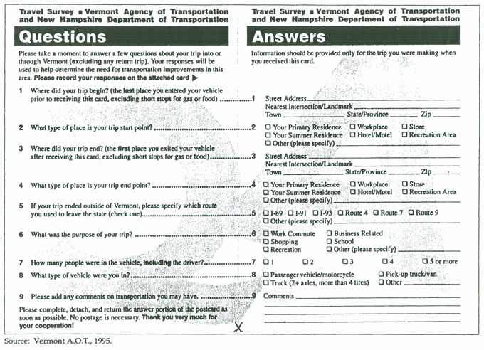
Figure 15.5 Sample Vehicle Intercept Mailback Survey Form from Vermont
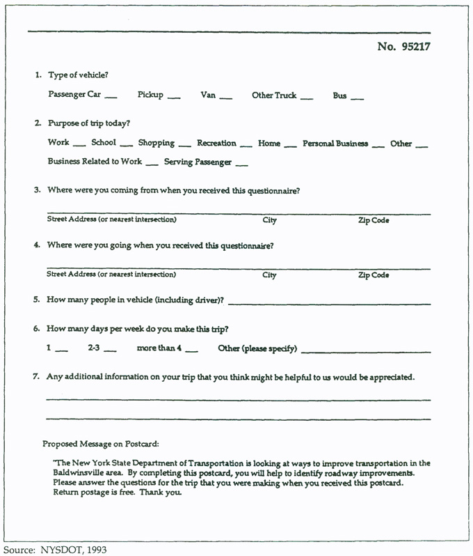
Figure 15.6 Example Vehicle Intercept Mailback Questionnaire from Upstate New York
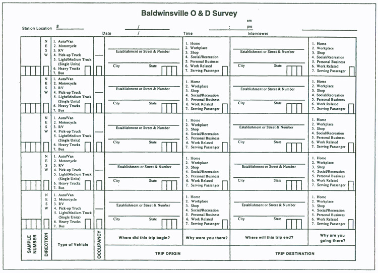
Figure 15.7 Sample Vehicle Intercept Interview Form from Upstate New York
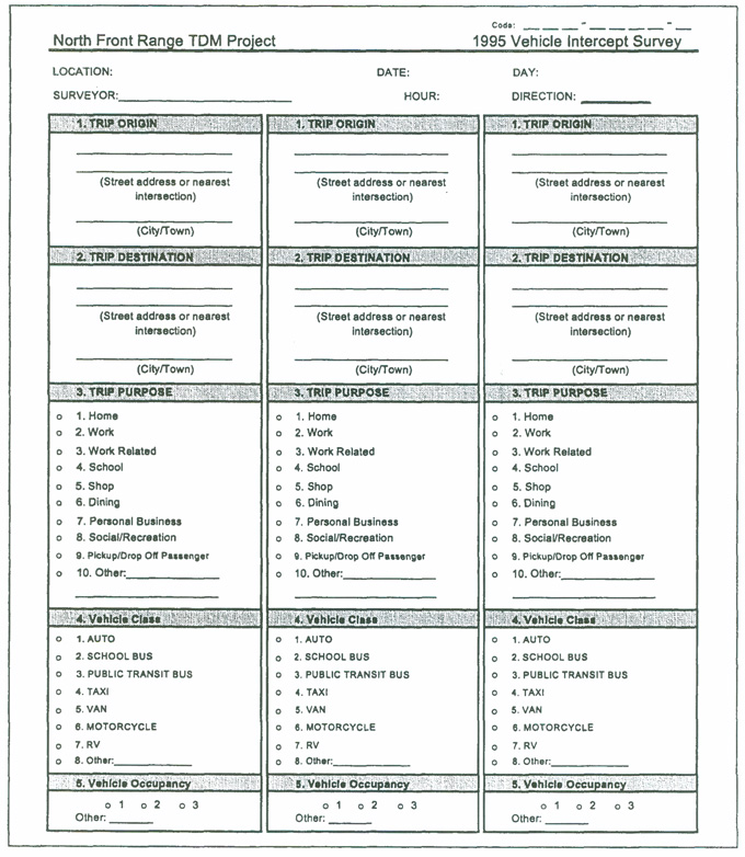
Figure 15.8 Sample Vehicle Intercept Interview Form from Northern Colorado
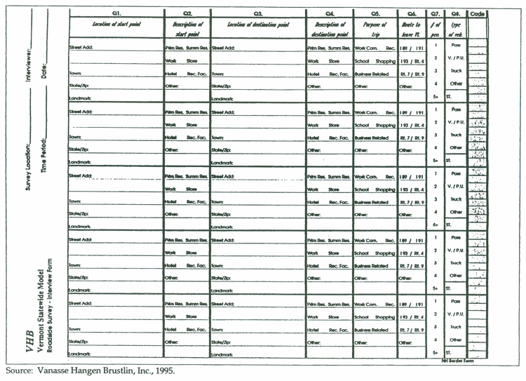
Figure 15.9 Sample Vehicle Intercept Interview Form from Colorado
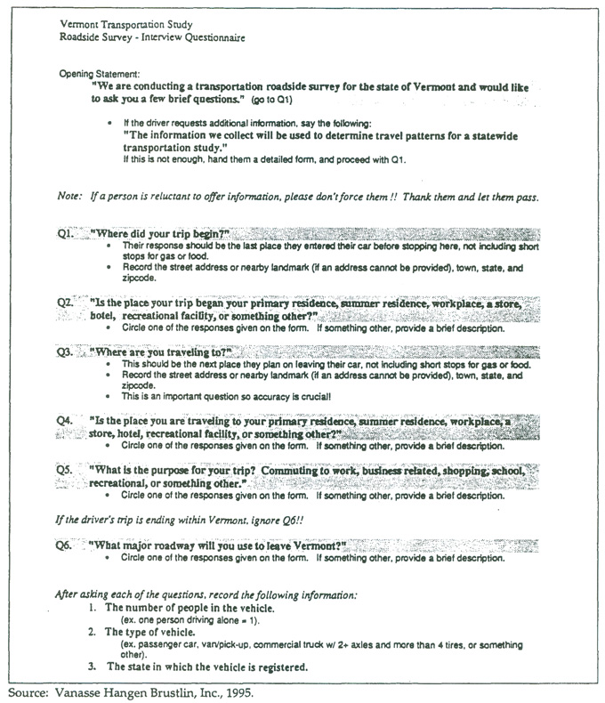
Figure 15.10 Sample Vehicle Intercept Interviewer Script
15.7 Pretesting
The pretesting requirements of the vehicle intercept and external station surveys will be dependent on the survey method selected. The survey logistics, procedures, and instruments should be thoroughly pretested before the full survey is implemented. Depending on the survey method chosen, the number of roadways (and in the case of the License Plate Survey, the number of lanes per roadway) should be identified to test the survey instrument, surveyor organization, and survey response rates under different conditions. These conditions may include surveying for peak-periods and daily conditions on different roadways to identify any problems that may arise through the conduct of the survey.
Fully implemented survey procedures should be pretested on at least two roadways with different characteristics, such as a freeways, highways, and arterials. For example, the entire survey method should be tested for an all-day period, generally from 6:00 a.m. to 6:00 p.m. The pretest staff should include the designers of the survey procedures and forms, survey supervisors, and key surveyors hired to provide support in the fully implemented survey. The surveyors conducting the pretest will use the same procedures and techniques identified for use during the survey training sessions.
The pretest requirements for the License Plate Survey will be more rigorous than the other survey methods. This pretest should include filming one lane in each direction for a selected multi-lane-divided highway and a two-lane state route. In this case, the fully implemented survey procedures should be followed from videotaping, license plate identification and processing, transfer of license plate information to the local DMV, transfer of address information to the project sponsor(s), mailout and collection of returned questionnaires, and questionnaire processing.
Pretesting for the Roadside Handout and Interview Surveys will be very similar to one another regarding the number and time periods of locations selected for pretesting and should be the same as conducted for the License Plate Survey pretest (6:00 a.m. to 6:00 p.m. for two roadways). However, slightly different pretesting needs are required for the Roadside Interview Survey to refine surveyor interviewing techniques. The pretest should be used as an opportunity to help surveyors refine their interview style and interview times before the fully implemented survey begins.
Because of the high cost of setting up a survey station, pretests are usually conducted at one of the sample locations. If the survey effort works well, the pretest data are used. To do this, the survey team should schedule one or two survey locations several weeks ahead of the rest. The results of the early survey can be evaluated, and procedures may be modified, as needed, before the general data collection occurs.
After completing the pretest, a debriefing meeting should be held to identify any discrepancies in the survey procedures. The survey control sheets (which vary by the selected survey method) should be rigorously examined after the pretest for discrepancies and uncontrolled information. The information contained in the returned questionnaires should also be processed immediately to identify any potential problems associated with respondents filling out the survey properly. Frequency distributions should be conducted on each question to determine the validity of the survey instrument.
15.8 Training and Briefing
Training methods will vary according to the survey method chosen. License Plate Survey training may require license plate identification and geocoding while the two roadside survey methods will require additional training. In general, survey staff training should consist of a project briefing and demonstration of the surveyor responsibilities. In addition, surveyors should be provided with the necessary materials and procedural notes to conduct the survey. In cases in which local data collection firms are hired, it proves highly useful for the project sponsor(s) to train survey administration and surveyor staff. Typical survey training procedures include:
1. Project Briefing – The project sponsor(s) should hold a project briefing for all hired survey staff (or local contractor survey staff). This meeting should be used to describe the background and purpose of the survey, and the administrative procedures to be followed during the course of the survey. At this point, all surveyors, including the “break” or replacement surveyors, should be given their survey assignments and work schedules.
2. Survey Demonstrations – The surveyors should be given individual demonstrations on the procedural conduct of the surveys. This includes describing the tasks of the surveyor regarding responsibilities for distributing (handing out) survey materials to drivers and/or collecting travel behavior information (interviewing or license plate data collection). The traffic control setup and breakdown requirements for each of the roadside surveys will also be demonstrated during this step.
3. Survey Materials – Each surveyor should be given the appropriate survey materials and supplies at the start of his/her survey shift. The materials provided are dependent on the scale and method of the survey to be undertaken. The materials for conducting the License Plate Survey will be provided by the contractor hired by the project sponsor(s). The materials identified below are intended to provide basic guidelines for each roadway to be surveyed using either of the roadside survey methods:
- Individual packages containing questionnaires to either hand out or tally responses, pencils for tallying responses, and large pencil erasers;
- Survey assignment sheets;
- One or more envelopes per specific time period and direction;
- Traffic cones and advance warning signs; and
- Surveyor badges, hard hats, and (highly visible) safety vests.
4. Survey Procedures – Each surveyor should be provided with an outline (in writing) of the procedures described in the previous training sessions. In some cases, several copies of a letter describing the reasons for the survey may be enclosed with this package. The letter should be signed by the project sponsor(s) and should provide interested drivers with information about the survey. In addition, this will ensure that the surveyor will not be distracted from his/her responsibilities by answering questions about the survey that may be served through this letter. At a minimum, the procedures outline should contain the following information:
- Where and when survey crews are to meet at the start of the survey shift;
- The set up of the survey traffic control plan at the specified roadway location;
- How to determine which questionnaires are to be used for specific roadways, directions, and time periods;
- How to hand out questionnaires and/or conduct the interview and how to complete tally sheets for those drivers agreeing to participate in the survey;
- (Roadside Interviews) What to do with completed questionnaires;
- What to do with the survey control sheets that track the number of completed, incomplete, and refused interviews; and
- Removal of the traffic control equipment at the end of the survey shift.
- (License plate surveys) Procedures for transferring raw license plate data to the office, procedures for matching the license plate database to DMV databases, and procedures for mailing surveys.
- Office staff procedures to follow when completed survey forms are mailed back.
15.9 Interviewing and Questionnaire Distribution
This section describes the typical techniques used in Roadside Handout and Interview Surveys. For each survey method, the surveyor should be trained to solicit agreement of participation from drivers traveling on the selected roadways. Descriptions of surveyor interviewing techniques are described below for each survey method chosen.
15.9.1 Roadside Handout Survey
1. Set up the traffic control plan for purposes of providing advance warning to drivers of the upcoming survey.
2. Once questionnaires are handed out, surveyors should be trained to briefly describe the survey to solicit passenger participation. Topics covered include the purpose of the survey and description of the length of response time. Politeness and conciseness are required for each surveyor to obtain representative survey samples.
3. If passengers refuse to participate, surveyors should politely and quickly thank them for their time. If passengers agree to participate, the surveyor should distribute the questionnaires to potential respondents for mailback.
15.9.2 Roadside Interview Survey
1. Set up the traffic control plan for purposes of providing advance warning to drivers of the upcoming survey.
2. Surveyors should be trained to briefly describe the survey to solicit driver participation. Topics covered include the purpose of the survey and description of the length of interview time. Politeness and conciseness are required for each surveyor to obtain representative survey samples.
3. If drivers refuse to participate, surveyors should politely and quickly thank them for their time and move on to the next driver. If passengers agree to participate, the surveyor should ask the related travel behavior questions and tally the passenger responses. The surveyor will be equipped with several survey questionnaires, a clipboard, and pencils to tally passengers’ responses. The surveyor should limit individual interview time to one to two minutes.
4. Surveyors should record all collected information neatly and accurately on the questionnaire forms. During the slack periods, the surveyors should use the time to code each questionnaire for all information other than the origin and destination data obtained during the interview.
5. Surveyors will be responsible for organizing questionnaires collected from drivers by uniquely coded time period and one-way roadway manila envelopes for data processing/checking purposes.
The surveying and interviewing techniques for each survey method described above are very similar. Variations of these techniques can be used by the survey team to respond to unique situations likely to be encountered in different areas throughout the country.
15.9.3 Additional Administration Issues
The organization plan outlined previously in this chapter identifies the staffing analysis, hiring methods, and supervision required for each survey method. Additional administrative support issues should be considered before the survey is fully implemented. The requirements for this administrative support include:
· Developing the necessary forms such as the questionnaires, control sheets, and surveyor assignment sheets;
· Providing schedules to survey crews (make sure surveyors and film crews will show up at their scheduled times);
· Developing a manual of survey instructions;
· Developing and conducting the surveyor training program;
· Specifying and assembling survey materials including surveyor badges, vests, hard-hats, pencils, clipboards, envelopes, traffic cones, and advance signs;
· Conducting the pretest; and
· Ensuring the appropriate level of police enforcement;
· Establishing a criteria for cancellations due to weather, and a plan to notify crew members.
This material must either be compiled and/or purchased at least one month before the implementation of the full survey. Additional materials, especially cones, and surveyor vests, and hard hats may be required for purchase as a contingency.
15.10 Coding
Vehicle intercept and external station surveys are coded using similar procedures as for other surveys described in this manual. In the case of the vehicle intercept, similar techniques are used to code the mailback/self-administered questionnaires obtained from the License Plate and Roadside Handout Surveys. The survey questionnaires are typically designed to be self-coding (except for the origin-destination information), where each survey response can be coded to correspond to its answer check box number.
Roadside Interview Survey coding can use the same techniques as the other survey methods. For example, the interviewers typically code the motorist responses into the check boxes on the questionnaire form, either by tallying motorist responses directly onto the forms or by directly entering responses into the survey databases on hand-held computers. Data coding can be completed manually or entered directly (using hand-held computers) into the coding database, by motorists completing the self-administered mailback survey, or by CAPI.
The survey data are typically punched into a numerical ASCII data block for a specified width and length as determined by the number of questions/responses and sample size of the survey. Individual survey questionnaire responses are typically given an identification number to track the responses for each vehicle surveyed. Survey origins and destinations must be geocoded to identify the geographic locations of the vehicles surveyed. Chapter 14.0 provides a detailed discussion of survey geocoding techniques.
15.11 Cleaning and Editing
The requirements for data editing the returned questionnaires is very similar for each selected survey method. However, the requirements for the License Plate Survey also require the additional task of editing and cleaning license plate information gathered from the videotapes and addresses obtained from the motor vehicle departments. Since turnaround time is critical, electronic data file transfer is becoming increasingly popular. Requirements for the Roadside Interview Survey consist of ensuring that all responses are tallied legibly and accurately by the surveyors. The questionnaires for each completed one-way roadway trip should be edited as soon after collection as possible to ensure that the questionnaire represents a valid response. At the end of each day, the trip envelopes should be opened and the control sheets should be checked for completeness.
For each survey method, the number of completed questionnaires and blanks should be tallied for each trip. Once the editor is satisfied that the trip information is complete, the questionnaires returned for that trip are sorted. Blanks can be discarded while the completed questionnaires should be sent for data entry. Each completed questionnaire may not have all questions answered. Therefore, the rules to identify a completed questionnaire should be given to the editors. Generally, a questionnaire is considered usable if the origin and destination of the trip, trip purpose, vehicle occupancy and time are filled in and codable. In addition, some models may also require demographic information such as home location, income, household size and auto ownership.
Cleaning the data once it is entered begins with range checks. For example, if the possible answers to a question are numbered 1-4 and the non-response is coded as 9, then all answers between 4 and 9 must be erroneous. In addition, certain cross checks must be performed to verify the accuracy of the data. These types of checks are called logic and consistency checks.
15.12 Survey Expansion
Survey record expansion and weighting depends upon an accurate, 100% count of traffic at the survey site during the day of the survey. Ideally, this count should be stratified by hour, and type of vehicle (auto and truck). The survey records are then assigned a combined expansion/weighting factor by hour and type of vehicle. Quality assurance checks should be made to ensure that the sum of the final valid survey records' expansion factors equal the observed total vehicle trips on the day of the survey. A final adjustment factor may be added to adjust for the day of week and seasonal variations in traffic. This can be done by obtaining the average annual daily traffic volume from the jurisdiction's highway department and comparing it with the survey day counted traffic.
Collecting External Data Using Bluetooth Technology
Field Practices in External Survey Data Collection
ALPR Camera Surveys in Ohio
Estimating Through Trips Using a Two-Phased Logit Model
Synthesized Through-Trip Models & Economy-Based External Trip Models for Small and Medium-Sized Urban Areas
REFERENCES
U.S. Department of Transportation, Federal Highway Administration. Urban Origin-Destination Surveys, Washington, D.C., 1973 (reprinted 1975).